

A storm that formed off the Aleutian islands is preparing to move inland over western Alaska with predicted winds of up to 100 miles per hour, record snowfall and flooding along the coast. The National Weather Service (you might recall it as one of those “costly” federal agencies Republicans thought should have its budget drastically cut earlier this year) is calling it a storm of “epic” proportions that may become the largest storm to ever hit Alaska in recorded history:
(Reuters) – An “epic” storm was bearing down on western Alaska on Tuesday, the National Weather Service said, warning that it could be one of the worst on record for the state.
The storm, moving inland from the Aleutian Islands, was expected to bring hurricane-force winds with gusts up to 100 miles per hour, heavy snowfall, widespread coastal flooding and severe erosion to most of Alaska’s west coast, the National Weather Service said.
“This will be an extremely dangerous and life threatening storm of an epic magnitude rarely experienced,” the service said in a special warning message.
Another NWS scientist categorized it as comparable to a hurricane:
Jeff Osiensky, NWS regional warning coordination meteorologist, told the Anchorage Daily News the storm was huge.
“It’s so big,” he said. “It covers 750 to 1,000 miles almost in breadth. These things get named hurricanes down south and get a category. It’s that magnitude.”
Residents of low-lying areas in Nome, a town of 3,500 on the southern Seward Peninsula, were ordered to evacuate while people in other villages such as Teller were also moved to higher ground Tuesday.
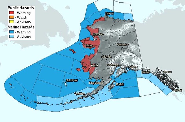
Evacuations of the likely affected areas are already in progress. Here is a weather map from the NWS website showing the regions predicted to be impacted by this storm:
One reason this storm’s impact may be so great is lack of sea ice in the Arctic Ocean and Bering Sea:
Posing an additional threat is the lack of sea ice off northwestern Alaska, forecasters said.
The last time a storm of a similar magnitude was sent in the same northward direction was 1974, but the sea surface was much more frozen then, Brown said.
“History tells that the sea ice helps subdue the storm surge,” Brown said. “With no sea ice there, we could see the full brunt of that 6- to 9-foot storm surge.”
For those of you unfamiliar with the recent warming trends in the Arctic, the last 30 years has resulted in a decline in Arctic sea ice, both in extent and total volume. In particular, sea ice over the last decade has shown a marked decline as temperatures have risen in the Arctic dramatically.
The analysis found 2010 approximately 1.34°F warmer than the average global surface temperature from 1951 to 1980. The record temperature in 2010 is particularly noteworthy, because the last half of the year was marked by a transition to strong La Niña conditions, which bring cool sea surface temperatures to the eastern tropical Pacific Ocean. A chilly spell also struck this winter across northern Europe. The event may have been influenced by the decline of Arctic sea ice and could be linked to warming temperatures at more northern latitudes.
Arctic sea ice acts like a blanket, insulating the atmosphere from the ocean’s heat. Take away that blanket, and the heat can escape into the atmosphere, increasing local surface temperatures. Regions in northeast Canada were more than 18 degrees warmer than normal in December.
The loss of sea ice may also be driving Arctic air into the middle latitudes. Winter weather patterns are notoriously chaotic, and the GISS analysis finds seven of the last 10 European winters warmer than the average from 1951 to 1980. The unusual cold in the past two winters has caused scientists to begin to speculate about a potential connection to sea ice changes.
Let’s all hope that the people in the danger zones can be evacuated in time, and that the extent of the damage will be less than currently forecast.


