
This info was brought to my attention from an article by the BBC on the recent release of the United Nations Environment Programme‘s amazing “One Planet Many People” Atlas.
I guess I’m not surprised by the content but the comparisons are amazing.
Here is the first pic with an explanation after the jump, follow me please.
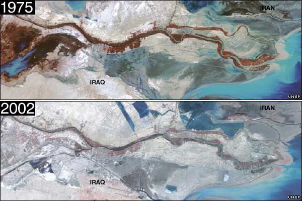
What you are looking at is the Southern tip of Iraq and neighboring Iran near al Basra. The dark purple color you see in the 70s is the once lucrative fig farming industry along the Shatt al-Arab estuary. This once thriving crop has been destroyed by, “[t]he UN estimates war, pests and salt have destroyed 14 million palms.”
On a side I want to look at a recent article from Reuters covers the problems of the current invasion and occupation of Iraq
“Iraq is the worst case we have assessed and is difficult to compare. After the Balkan War we could immediately intervene for protection, such as the river Danube, but not in Iraq,” Haavisto, a former Finnish environment minister, said on a visit to Jordan to meet with Iraqi officials.
…
The situation became worse after the 2003 U.S.-led invasion, in which depleted uranium munitions were used against Iraq for the second time and postwar looting and burning of the once formidable infrastructure caused massive spills and toxic plumes, Haavisto said.
“The bombing and war carried a cost but the looting cost the environment more, such as in the Dora refinery or Tuwaitha nuclear storage,” Haavisto said.
“There has not been proper cleanup and only assessment work at some of these sites. Very little has changed and Iraqi teams are in the process of getting in some of these locations.”
The U.N. official was referring to the 56 square km (22 sq mile) Tuwaitha complex south of Baghdad where 3,000 barrels that stored nuclear compounds were looted.
In the Dora depot on the edge of Baghdad, 5,000 barrels of chemicals, including tetra ethylene lead, were spilt burnt or stolen, a U.N. survey showed.
Contaminated sites near the water supply also include a 200 square km (77 sq mile) military industrial complex, torched or looted cement factories and fertiliser plants, of which Iraq was one of the world’s largest producers, and oil spills.
“Iraq was a modern industrial society in many ways. The chemicals are very risky on its future. The more time passes the more consequences on health,” Haavisto said.
He said postwar assessment of the environmental damage was proceeding despite threats to the 1,000 staff of an Iraqi environment ministry, set up as an independent unit after the American invasion.
The field studies will eventually include depleted uranium, a toxic, heavy metal used to make bombs more lethal, of which the United States used an estimated 300 tonnes in 1991 Gulf War and an unknown quantity during the last invasion.
Back to the atlas…
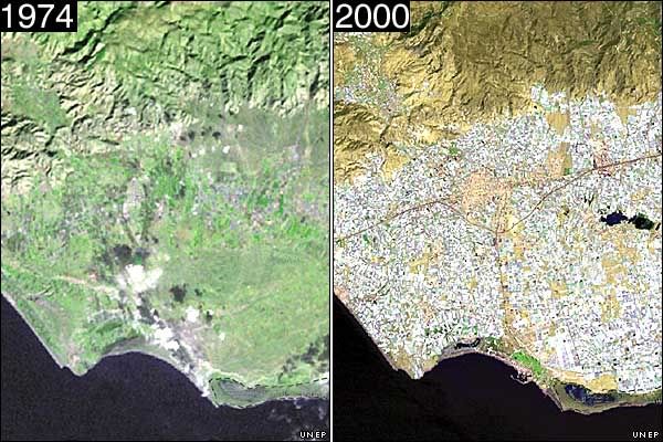
This is a shocking change in Spain; I’m, however, not too worried by the view. What was once traditional farmland has been replaced by greenhouses. So at least the land is being used for nature not industry, but the Fertilizer can be problematic. I’ll let people in the comments clear that up.
This pic has two interesting points
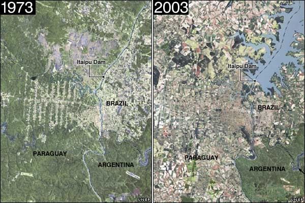
First notice the dam and the change that occurred. Second notice the lack of change in Argentina as opposed to Paraguay and Brazil. What remains in Argentina was once a larger Iguazú National Park. This is an example of a victory for those fighting deforestation; well at least a victory in Argentina.
There are a few more pictures at BBC here.
UNEP has an extremely informative press release here.
Originally posted at my blog.


more tellin pics from Plutonium Page here.
and all those graphics. All I can say is that you hate
freedom and you hate America.
just kidding.
I cannot handle anymore information. I’m going to go out
on my bike now to see what is left of the world.
.
The marshes were intentionally destroyed by Saddam Hussein, because of the Shia uprising in Southern Iraq at the end of Gulf War I.
Research project of the Laboratory of Sedimentary Petrology and Paleontology (Paris-Sud University, Orsay) and the Geological Survey of Iraq (Baghdad). The study was made shortly before the onset of the war that destroyed most of the natural environments of Mesopotamian swamps and lakes, and consequently the amphibious villages of the Arabian Reed Culture.
Oui – Liberté – Egalité – Fraternité
Greenhouses on fertile land begs the question: why? To put greenhouses on land that cannot be farmed is one thing – this is just one example of how Spain is trying to monopolize Europe’s fruit (vegetable) production – it is a question of being able to maintain itself within the EU – and one of the many reasons I am against it.
(On a side note I remember when Austria joined the EU, it became illegal for Austria to continue to subsidize its vast mountainside dairy farms (milk) – primarily because of the cheaper mass produced milk from Belgium. It was clever enough to rename the subsidies to “Forestry services” – so the dairy farms remain).
I fear countries like Greece will follow suit, since their exports are more often than not natural goods (and tourism – so the nice homes for Mercedes exporting citizens will bloom as well). Greece at least has a choice right now whether it wants to become another Spain or a playground for the rich.
In any event more about Spain. They are ruining their land, which is becoming more and more prone to soil erosion, pesticide contamination etc… The following is from an article from The Christian Science Monitor – but a quick google search will give you much more info.
It has also increased soil erosion, water usage, and pesticide contamination in an area so environmentally sensitive that experts estimate that 20 percent of Spain is turning into a desert.
I know nothing about the land under these greenhouses, but thank you for your views 🙂
The only thing that I would say in defense of the use of a greenhouse, is that greenhouses offer a more controlled and efficient environment for production. But it wastes a free source of energy in the Sun; something I suspect Spain gets plenty of. Therefore, I would say I’m against it as well.
.
Another illustration, thanks to Reuters. Excellent coverage in your diary and links to sites.
(Reuters) -- Iraq's environmental problems- among world's worst - range from a looted
nuclear site to oil spills.
Lack of spare parts and Iraq’s inability to maintain pollution standards during two previous wars and more than a decade of crushing sanctions have damaged the environment, including the Tigris and Euphrates rivers where most of Iraq’s sewage flows untreated.
[Many parts of Baghdad Sadr City, streets are covered with sewage – Ed]
Oui – Liberté – Egalité – Fraternité