
OK folks, I have to go to bed soon, but I think this is important.
Hurricane Wilma has strengthened over the last 12 hours in nearly unprecedented rapidity. The folks on the weather channel are just about choking on their tongues trying to describe this right now.
As they say in Star Wars : I’ve got a bad feeling about this.
More on the flip.
Here is what Steve Gregory, from Weather Underground had to say on his blog. This sends chills down my spine.
RECON JUST REACHED. WILMA IT IS AN UNBELIEVABLE SUPER CAT 5 –> 901MB, WITH 162kts!!!!
OVER A 50mb DROP IN 5 HOURS – THE SAME RATE AS RITA. 2 MORE HOURS OF THIS IT COULD EASILY BREAK THE ALL TIME
RECORD LOW PRESSURE IN THE ATLANTIC BASIN OF 888MB.IMAGERY SUPPORTS THIS. And the 850mb height was reported at 516 meters.
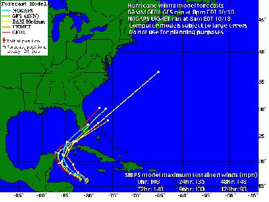
The models that have been run lately on their site show this hurricane hitting Mid/Southern Florida in a few days. (pictures borrowed from Weather Underground).
From Jeff Masters’ blog, here is a map of the water temps in the Gulf right now:
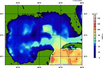
From Jeff:
Wilma is currently traversing an area of high oceanic heat content (see Figure 1), and this heat content will not significantly fall unless Wilma passes north of the Florida Keys. I would expect an additional 10 mph reduction in Wilma’s winds if she makes landfall in Florida north of the Keys, due to the lower heat content of the water.
It should be noted that he last updated this several hours ago, and was predicting a cat-2 at landfall. I’m pretty sure he will be changing that prediction when he gets up in the morning, but if the relative wind speed prediction stays the same, this could be disastrous.
The eye of the storm is only 4 miles across right now. This is an amazingly intense hurricane.
Note : I am not a meteorologist. People who are are using words like explosive and phenomenal to describe what is going on right now. Phrases like I’ve never seen a drop in pressure like this in an Atlantic Basin hurricane and I’ve never seen an eye this small.
Wikipedia has folks keeping their page extremely up to date, as always.
Update [2005-10-19 9:31:26 by ejmw]:From Jeff Masters:
There has never been a hurricane like Wilma before. With an unbelievable round of intensification that saw the pressure drop 85 mb in just 12 hours, Wilma smashed the all-time record for lowest pressure in an Atlantic hurricane this morning.
Thanks to brinnaine and blueneck for keeping the light on while I got some much needed shuteye.
Update [2005-10-19 22:24:28 by ejmw]:Wilma’s pressure came back up today to 892 mb, which is 10 mb higher than it’s frightening low of 882 mb.
Note that this still means that Wilma is as strong as the third most powerful hurricane ever measured, the <a href="http://en.wikipedia.org/wiki/Labor_Day_Hurricane_of_1935"Labor Day Hurricane of 1935.
From Jeff’s weather blog:
Peak winds measured at flight level were 141 knots in the southern eyewall, compared to 162 knots measured this morning.
(…)
The eye diameter measured by the hurricane hunters was still a very tiny 5 nm, and an second concentric eyewall with diameter 10 nm has formed. This indicates that Wilma may soon undergo an eyewall replacement cycle, and will weaken to a Category 4 storm.
After the eyewall replacement cycle is complete, the hurricane could potentially strengthen again, but hopefully it will be headed over cooler waters or land by that time.
In addition, if it hits the Yucatan peninsula, that could help to weaken it significantly as well. While this is good news for Florida, it is very bad news for Mexico, as there is a chance that it may hit as a cat-4 at landfall.
Here are the latest computer models from Weather Underground:
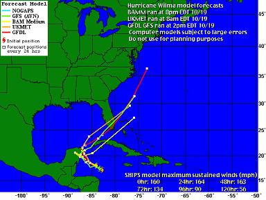
I think that the models tomorrow will tell us more, as there is a great degree of unpredictability right now. You can see that the computer models are much less tightly clustered than they were last night and earlier today.
I’ll try to keep this updated as long as it stays on the rec list. Folks on dial up, let me know if this starts getting too slow and I’ll start to remove some of the old pictures or start a new thread.


Because the visible satellite ones are dark, at this point.
IANAM. Please see the National Hurricane Center website for the latest official warnings and forecast track. The links provided by ejmw above for the blogs of two real meteorologists are excellent links for some more speculative, but very good information and graphics.
WILMA is tied, as I type this, with the Labor Day 1935 hurricane for 2nd lowest recorded pressure ever for an atlantic hurricane.
Ditto ejmw’s concern for FL. Stay tuned everybody. It could hit farther north than they are predicting, so EVERYBODY FROM MS,AL, N FL also need to WATCH CLOSELY!
Historically, this late in the season, most hurricanes will hit FL. However, this storm is big enough and strong enough to MAKE ITS OWN PATH. From what I’ve seen of the forecasting models over the past few years, they have more early trouble predicting the landfall target when the storm gets this strong.
We should know better where landfall will occur after WILMA makes its entry into the Gulf of Mexico sometime around Friday.
Here’s a link to a site with lots of links to satellite imagery and other tropical weather websites. If you follow all the links on this page, you’ll be on your way to catching up to me. I have over 150 links to various sites concerned with tropical weather, as well as real-time polar and oceanographic info. If there is enough interest as Wilma progresses, I will share some real cool weather links with ya’ll….
Thank you for such incredible links to sats and photos!!!
Mother Jones rans a story about the warming and the “Hockey Stick” – I can’t get that particular story up – I keep getting 404….
http://news.bbc.co.uk/2/hi/science/nature/3569604.stm
THANKS! There’s more to come, keep checking back. I gotta run right now, but tonight or early tomorrow I’ll be posting more links!
Here’s another link to lots of tropical weather links.
The Hurricane Hunters can’t believe it, so they’re recalibrating and going back thru the storm to re-measure. The central pressure recorded during the previous run was 884 millibars.
I believe 884 mbs, whether they ‘revise’ it or not. It would be in the interest of the Thug administration to force the National Oceanic and Atmospheric Administraion to revise it downward. We couldn’t have it look even more like they are idiots for ignoring GLOBAL HEATING. That might be worth another point downward in their approval ratings in the polls.
There is good reason to believe the original measurement, imho, due to the extremely small eye and the extremely hot sea surface temperature(sst). Currently SST’s and the TCHP(Tropical Cyclone Heat Potential) measurements allow for a cat five storm well into the Gulf.
Here’s what Jeff Masters has to say this monring:
Wilma: strongest hurricane ever
Also, MSNBC is reporting that the Florida Keys are beginning to evacuate TODAY.
See where those southernmost tracks are yellow over the peninusla, just west of Miami? Mark that with an “X.” That’s my house.
OK, now I’m worried. I have an aunt and uncle in Naples and they are NOT taking this seriously. They’re telling my dad that “We’ve got our storm barriers up, why would we need to leave?”
They still need to ask that after what they’ve seen this year?!?
From Jeff Masters at Weather Underground :
Well, they’re old and they think they’ve seen it all.
When you’re young, you think you know it all.
When you’re old, you think you’ve seen it all.
Either way, here are some testimonials to maybe help convince them that they haven’t seen this before (though it will probably hit FL as cat-2 or cat-3, not how it is now):
Enjoy this:
Multi-Dimensional Imagery from polar orbiting and geostationary satellites operated by the National Oceanic and Atmospheric Administration-NOAA.
and:
Scroll down on this Ocean Surface Winds Derived from the SeaWinds Scatterometer webpage and click on the area you want to view up close. It’ll give you a recent view of the wind field of the storm as measured by satellite.
and:
Oceanweather, Inc. will give you a graphical representation of wave heights associated with the storm. Just click on the area you want to view up close.
Do you realize this is a W hurricane? Some Florida friends pointed that out to me and they said there’s never been a W hurricane before. Something is coming your way with your initial on it, George.
that according to the National Hurricane Center, Washington DC is in fact in their 5-day cone.

Do you think they’ll tell George, or just let him keep riding his bike through it?
To hit Florida and then DC?
I guess G-d is trying to tell the Bush Boys something. (snarkasm)
Remember all those fools who said G-d was trying to send a message to New Orleans… ugh.
This has been one of the predictions for Global Warming: an increase in the number and severity of hurricanes.
This has been the most active hurricane season on record.
This has been the season with the most powerful hurricanes on record.
Now couple with:
is concrete evidence for Global Warming.
Note: Global Warming is a completely separate issue from the problem of the effect of human produced Greenhouse Gases. It is possible to have GW without any human causation. So nobody has to prove a human/GW connection to prove GW. (So there. Nyah)
What makes all this even more frightening is that (all global warming implications aside) we are merely on the upswing of the natural ~25-30yr hurricane cycle.
Next year could very plausibly be worse than this one.
And the year after that, even worse. And so on.
1) What you said.
Now couple with:
is concrete evidence for the linkage of Human activity to CO2-caused Global Heating.
They are one and the same. It is not NECESSARY to to prove one to prove the other, but the evidence is Very Clear. It is of course not necessary to prove that 2+2=4 in order to prove that 1+1=2; however, the same system of rational thought that gives rise to one solution also provides the solution for the other.
They are NOT completely separate issues. So there. Pffth.
I am so grinning.
I guess this is what amounts to a flame war on BT this week?
“So there. Nyahh.”
“So there. Pftth.”
Accompanied by smiles from all who read it.
I wrote:
To which blueneck responded:
I fully expect Knoxsville Progressive to contribute by adding:
Oh I agree the rise in Greenhouse Gases (methane, CO2, & etc) from human activity is the most likely major concrete cause of GW and that the evidence for the same is Very Clear. But I can’t prove that it is a concrete cause.
Thus the narrower statement.
Notify the blog-authorities AT ONCE! We have a bonified, certified, PROVABLE flame war here! Get Booman And SusanHu on it, quick. And where are shirlstars and diane101 when we need ’em????
Fooey!!and furthermore- Pshaw!
NRL Monterey Marine Meteorology Division has the best array of standard satellite imagery available in one place on the net, imho. Sometimes it can get get bogged down and move kinda slow, but it’s very complete.
[NOTE: There will be a PLANNED site outage today from 1200-1215 PDT at the above listed site.]
a roll of reynolds wrap coming out of my ass… but I’m getting a bit suspicious of every fucking time the news starts to actually REPORT or something starts to happen.. there’s a HURRICANE.
Global Swarming – Killer Bees
Global Warming – Killer Breeze
fuck it, I blame Bush and his cabinet of non-advisors like ExxonMobile (they say there’s no such thing as Global Warming) and his admin of warmongers.
Heh. Might this be what you’re talking about?
Or how about this? A little older, but still fun.
The first site, at the bottom, asks if you want to be a born again Christian… ACK! LOL
I am curious as to why Bush ran to Colorado NorCom during Rita. And HAARP does scare me…
But nawww. I just blame Bush today because I have a wild hair up my bum today. 🙂
Great Diary Ejmw! Thank you- I shot your diary over to a hockey pal of mine.
Janet, Janet, how many times do we have to tell you the tinfoil goes on your HEAD!?
it wouldn’t chafe as much… 🙂
My in-laws were in Florida on a vacation. I called and they are already in CT. On their way home to their flooded NH town.
They voted for Bush….
Guess they left while W was still a troppie.
All I know is that when I went to bed last night, Wilma was a tropical storm or Cat 1. I wake up this AM and it’s a goddamn Cat 5?! Wha????
People have got to stop playing around w/ global warming. We all know it exists, ESPECIALLY the foulest polluters–how much longer will they continue to avoid accountability?
he’s home under the weather… and inbetween Herbie movies we saw a bit of the weather channel because Gram and Gramps were in Florida.
He goes:
W worst hurricane EVER!
W worst President EVER!
Be still my bleeding heart! 🙂
What a great guy he is!
Well, shite. Remember this diary?
When I went to bed last night, Wilma was just an annoyance. Now this. For the Tribber whose folks live in the Marco Island/Naples area, take heart. They’ll have a mandatory evacuation, if the municiple gov’t. has any comptence. However, there’s only one way north, up I-75 and one real way west, Alligator Alley, and one harrowing two-lane way west, Tamiami Trail. Good luck. Hopefully, folks will start leaving today and the state can avoid a mess like those fleeing Houston experienced.
As for us, there’s nowhere to go. Can’t flee east — that’s the Atlantic; can’t flee west — that’s the teeth of the storm; can’t flee north — that’s the projected future path of the storm; can’t flee south — the Keys don’t allow folks in when hurricanes are around.
So, it’s hunker down on my still partially flooded property, that way from visits by Katrina and Rita, and due to very wet Sept. and Oct. It’s prepare to live through this behind shuttered windows. Half of them are up, but not on the west side — nine windows to go. Thank god we’re inland.
We’ll hope the cooler Gulf waters of the SW tip of FL drop the force of the storm before landfall. I’m also hoping for a sooner, rather than later hard right turn by Wilma. Hello Cuba libre!
To my Canadian friends: Could you please send a strong Arctic blast south, tout de suite?
I wish you the very best of luck. IANAM, but I do think that the further north this ‘cane goes, the weaker it will be when it hits. However, I do happen to believe it will go to the north side of the projected path. Some are saying now that you may have an extra 18-24 hours to prepare, compared to the early projections of landfall on Sat morn., so get crackin, and don’t count on a cold blast…please.
I say we impeach Bush for receiving the mother of all BLOW JOBS.
Won’t Wilma be passing over an infamous little US encampment on the western edge of Cuba at its most powerful? What the hell will happen with those open cages in a Cat 5?
Oh no, stupid me – Guantanamo is on the eastern tip – sorry
And here I was just about to respond, assuring you that I’m sure the cages would be fine. The wind will pass right through ’em.
But probably not a lot of fun to be in that cage with 165 mph wind passing through them – and horizontal rain…
OH, you’re concerned about the PEOPLE. Silly me ;p
I was merely snarking the idea that there are probably people who do care more about the cages than they do the ‘terrorists’.
My snark detection meter is malfunctioning…
The National Data Buoy Center hooks you up to the vast fleet of weather data buoys in the Gulf of Mexico(and elsewhere). It allows you to click down into a single buoy and get cool stats like pressure, wind, sea surface temp, etc. that the buoy is reporting! Just choose the box that covers the area within which you want to find a buoy and keep clicking. It may take a few clicks to get there, but it’s way cool, especially if you get a buoy that gives you the graph over time of the changing conditions.
Next up The National Hurricane Center’s Latest Satellite Imagery page. It’s always a good place to go to grab the latest views. Check out the “GOES Storm Floaters”. That’s where the storm-centered images will be. Wilma is being followed by Storm Floater One.
Now for something a little more spectacular – The Mexican Weather Service’s full hemisphere satellite shots.
Click on the Globo-ir globe, it’s way cool!
More tomorrow. 🙂
I’m running at 31.2K here in the boonies.
Load time was still reasonable as of time on stamp with this post.
Sure do miss the 1.5 M I’m normally on.
Thanks for the reports, especially appreciated as I have no TV here. Great in some ways, not so great in others, but this little CRT screen suffices.