
What if we just set the ground rules for a High Speed Rail system and let projects be put together catch as catch can.
What would happen?
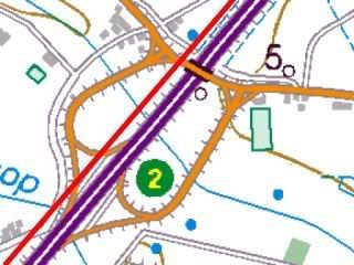
Well, I reckon it would end up looking something like this:

Notice that I do not show you the map of the US, but I bet you can guess most of the details (point to Chicago … point to Dallas … point to LA/Riverside … point to Florida). Where does this come from? From setting up some rules, and then following them. No master plan, just some basic ground rules. The details, under the fold.
Cross-posted from the Daily Kos
What rules did I use? Well, first there was some arbitary cut-offs.
- The initial set of eligible cities was restricted to metro area populations of 1 million or more.
- Eligible projects had to have an effective trip speed of 200mph and complete their journey in somewhere between one hour and three hours … though single legs less than an hour were allowed if they were part of a larger project. (Note that I used crow-flies distances, but this is a rough approximation)
- … and that was about it … the rest was determined by the Census and what one of those online city distance calculators told me.
The actual result is the solid red line network. If Memphis and the Research Triangle in NC both grow to 1m+, there will be two distinct networks … one for the west coast, and one for the east coast and middle west.
The dashed lines across the Rocky Mountains run through Salt Lake City, which in the last census was not 1m (but in the 900,000’s, so close), and El Paso, which in the last census was about 2/3 of a million. If you wanted to “connect” the two networks, those would be the natural point … but there is no real up-front reason to want to do that. Remember, these are point-to-point trips in comfortable, Economy+ or Business+ seating, not a multi-day adventure in a sleeper car in an old Hitchcock film. The fact that the networks connects just increase the variety of services that can be put on to meet different travel needs … but the idea is 1 hour to 3 hour trips, not going back to the days of coast to coast rail travel in Pullman cars.
Oh, and the dashed lines at the top are Canada … it just so happens that one the same rules, their four biggest cities could also be integreated into the network, so I sketched them in with dashed lines (and, because of the map I was drawing on top of, an arrow to point up to Vancouver).
That big star pattern at the top, a bit right of center is, of course, Chicago, and the big star pattern at the bottom, almost right in the center is, of course, Dallas. That’s just what happens under those rules. That just might have something to do with why Chicago and Dallas have the populations that they do … hmmmmm.
Note that there are a lot of “alternate routes”, and an “efficiency expert” would ask “which of the alternate routes do we follow”. If an “efficiency export” does that, please smack the efficiency expert upside the head for me. These are not routes. These are connecting pairs of cities of 1m people or more that trains travelling at 200mph (line of sight travel speed) place at 1 hour to 3 hours apart.
If your eye sketches out routes, its because its is normal, in the United States, for cities that size to be separated by distances like that.
As a note, the last Census was 2000, so this is pre-Katrina. However, the dashed line that runs from Dallas to Atlanta across the middle south is not an “alternate route”, “in case NOLA no longer qualifies”. It rather reflects the fact that Memphis and Nashville are getting close, and if they get over the line, that is what happens to the map.
What does this tell us about a High Speed Rail system?
We don’t need no effing master plan. We can draw up maps that show what happens if the country if fully built out according to some rules, and then if someone suggests changing the rules (and especially if they are a Congressperson, so agreeing to their suggestion may help get a policy passed), we can draw up a new map.
For example, suppose that someone says instead of each city in a pair being greater than 1m, the geometric mean (square roote of the product) has to be over a certain threshold. Draw up a new set of candidates, draw up a new map. It will be similar to the one above, though with marginal changes due to whatever differences the clever formula-creator was trying to achieve.
However, the 1m+ cities between Chicago and New York are simply packed too close together for the middle west to be left unconnected to the east coast under any reasonable set of rules … as long as we have high speed rail. Under “express” rail alone (roughly 100mph), important gaps start to pop up all over: Atlanta falls out entirely, dropping Florida to a local networks; Dallas disconnects from the Central Plains; Sacramento disconnects from Portland, Oregon on one side and from Los Angeles on the other.
In short, the US looks like it is made for 200mph High Speed Rail: it’s a natural fit. And going back into our history, at least in the the Great Lakes and the Plains … that is probably right. As soon as you start doing this exercise, the old rail-heads of the 1800’s jump into the network as key points … and as you go further west, the distances between those key points start to stretch out … tracking the rapidly accelerating trains across the second half of the 1800’s.
The final point that is dramatized by the map above is not shown in red, but in white … by no stretch of the imagination does the 200mph high speed rail system go “everywhere” under this … not even close. So if the high speed rail is not going through the town where you live … what are your options?
Actually, as a lingering legacy of the first age of Rail … they could well be pretty good. To make full use of the existing rail corridors still in use and available, we need to find a way to get a path for 100mph passengers and freight that is free and uncluttered of slow moving bulk rail cargoes. And so that is the planned topic of my next rail diary … though when it will appear, like present-day Amtrak, there’s just no telling.
Some final auxilliary notes (prompted by dKos discussion)
Given the number of times that it has come up, I do want to stress that 200mph means that trying to use existing rail Right Of Way is difficult, when it is not totally infeasible … and at the same time, it may well be that this Right of Way is probably better used for express freight, express passenger, local passenger, and bulk freight.
However, substantial stretches of Interstate Highway offer attractive HSR right of way. If built along the edge of the highway right of way (rather than the median), this means frequent “dives” to clear underneath highway exits. However, “dives” for High Speed Rail can be more energy efficient than with slower rail, because the train clears the dive so rapidly that it does not have time to lose very much momentum.
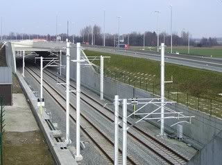
… and this from the European Tribune … in flat areas like Florida, this example from the Netherlands should give a good idea how it would look:
One could argue that the Interstate Highway program was established with a very substantial National Security component. Two of the major real National Security challenges faced by the nation are reducing this nation’s rapidly escalating dependence on imported energy and reducing its contribution to rapidly escalating risks from global warming. So devoting suitable portions of Interstate Highway right of way to help face up to these National Security challenges could be seen as only a means of paying back some of the support provided by the National Security establishment.
One could argue, that is, assuming rational people in government, which is a hope that is at the moment focused on the Congress.

A couple of observations.
Interstates
The first is about your suggestion of using the Interstate system for the rights of way. This may well be attractive but there are drawbacks, one of which you allude to.
This is the need for “dives” if you go alongside the existing roadways. These should be avoided and it would be better to make new bridges over the joint system than having rapid changes in levels. This in the end would be less expensive.
The other point under this heading is the road layout. High speed (or indeed any) rail systems rely on there being few bends and tight ones, that cars can manage easily, are out as far as rail is concerned. This is one problem of using existing rail networks for high speed services. While “pendolino” type tilting trains allow tighter curves than conventional trains, they are slower than the 200 mph than you want.
Non Inter-City Services
A new rail system, whether it runs alongside Interstates or not, is very expensive. It should therefore be utilised as much as possible and for most inter-city services you are probably looking at an hourly or half hourly service at most, the former being more likely as this the sort of regularity you get on say the British rail network. There is therefore a great deal of spare capacity. What you should also be looking at is to run a more regular “local” serice on these lines to serve commuter needs.
A similar proposal is in place for the new Channel Tunnel Rail link into St Pancras station in London. Existing services go into Waterloo Station (a little undiplomatic as the main runs are to Lille and Paris) on the original London network. This slows the service and takes capacity from the commuter network. The new connection will use “Javelin” trains based on the Japanese “bullet trains” as a new commuter service from north Kent into central London.
You may also want to bear in mind that other services could be economically viable. I am not sure if your propoal includes Las Vegas for example but a LV/Los Angeles line to service the casinos would seem attractive.
Actually my “proposal” does include LA / Las Vegas, because they are both 1m+ and fall within the distance threshold. If you find LA/Riverside, that spur heading to the northeast is Las Vegas.
And some routes are not included because they are too close together. There is little substantial advantage to Cleveland / Columbus / Cincinatti to be provided through High Speed Rail, when 100mph tilt-trains can likely make the full run in under 4 hours and include Akron, Canton, Newark and Dayton along the way.
Of course, each specific route (dots on each end) could be funded or not based on whatever actual criteria are put into place.
As to using the corridor for express commuters, that seems to be most attractive in the vicinity of the urbanized metro area, since a high speed corridor would by preference bypass the intermediate sized cities that would be the desired target for the Express and slower services. However, it is in the urbanized area that development of the new rail corridor would be most expensive, so that may well be a useful strategy in the approach to the city.
And on the interstates, yes, I was referring to the long straight sections between cities, not the bypasses, which have much more of a bend.
Two questions:
Given the obsession with “security” as witnessed by the newly elected Dems passing HR 1 and their continued “failure” to do anything about anything I tend to now side with people like Alex Jones. Yes, I know the very mention of that name clicks the off switch in millions but logically it makes more sense.
The Trans-Texas corridor is already underway. The local newspapers have been bought out, the subject is on the national media blacklist, billions are being spent on high tech electronic research in order to make this great divide the equivalent of the Berlin Wall. So, if they didn’t plan on a national rail network then I don’t thing they will let them cut through this “road”.
I am not sure what the first paragraph means. Who is Alex Jones? I was, I should note, out of the country for a decade til last summer, so a lot of “inside the US media bubble” things passed me by.
I should stress that this is not intended as a silver bullet, but just one silver BB among many.
The TTC is a separate issue to this, but yes, this could be part of the strategy to subvert the TTC. Since the corridor has to be electricified, there is no conceptual difficulty in having a pair of HSR tracks and a pair of Express Rail tracks side by side, with perhaps an additional bulk freight line with passing loops. The amount of land that saves compares to a truck/car based approach is massive …
… indeed, the TTC already includes rail in the cross section for bulk cargo (shipping American timber and mineral resources to the Mexican Pacific Coast to trade for Chinese manufactured goods). Basically for the land cost of one two lane Express trucking superhighway and associated buffer space, you get HSR, Express rail and freight. And undermine the effort to use non-unionized Mexican truck drivers driving goods in bond to KC, etc., so hopefully this could attract the support of the Teamsters.
That would entail establishing as a single project San Antonio / Dallas / Oklahoma City / Kansas City / St. Louis / Chicago / Detroit / Toronto / Ottawa / Montreal / Boston.
The HSR services would not run from one end to the other, but they certainly would not suffer from the flexbility of being able to run services to the large number of city pairs and triples in that corridor.
Its of course just one part, and probably not near the top of the list in terms of weight. Another part is mobilizing the support of people driving on worn down Interstates to have a moratorium on new Interstate construction and devote Interstate Highway funds to maintaining the system that we have.
I am sorry. If you have been out of this country for an entire decade then IMHO you my friend need serious how shall I say this “debriefing”. From my observations of business and media over a very short time media has merged toward the interests of corporate and as such is deliberately subverting the democratic process in America. TTC is only part of the merger into the NAU which again has been conspicuously ignored by what most now call MSM, mainstream media, or corporate media.
Ten years? Please don’t get too depressed, my expat was only one and it seemed like the movie “Invasion of the Body Snatchers”. Who are these “Americans”, these are not the people I left only one year ago.
A long time ago a decision was made to favor the auto over rail.
And Alex Jones leads into this subject. He is one of the premier “conspiracy” theorists. You may take what he says at face value or not but being removed from “American” culture for ten years I trust you should have far better judgement on this than even I do. Rail lines would make sense if they had not destroyed that capacity long ago.
But there is a lot of corporate interests that would be served by this system.
Indeed, that is one reason why Europe is building so many HSR lines as opposed to freight and Express passenger rail … there are commercial benefits.
Indeed, there is no reason why the HSR corridors can’t be used by FedEx and/or UPS courier freight trains.
While there are some short term corporate interests that lie in the direction of the long term economic suicide of the US … not all of them lie in that direction.
You might end up with something different if you were using the metro-area populations instead of the straight census figures. The population of the Memphis metro area, for example, has been in excess of a million for years — it’s currently 1.2 million, roughly twice the population of the city of Memphis itself. Metro Nashville, as it happens, is almost 1.5 million.
This is fresh on my mind because I happen to be from Tennessee, but I’m sure similar cases apply just about everywhere. Use the standard metropolitan statistical areas, and the number of 1m+ cities grows quite a bit. The Triangle (Raleigh-Durham and environs, in NC), for example, has a population near 1.6 million.
… but I don’t think I’d end up with anything less connected, so using the less optimistic numbers is, I think, a useful exercise.
And it should be the case that the urbanized area population will be especially attracted to the HSR. Possibly if I was doing a more refined analysis, I would do sensitivity analysis on various weighted averages of urbanized area and SMA populations.
One problem of SMA, of course, is that it is subject to change due to changing political boundaries that do not have an immediate effect on travel markets. But it is politicized precisely because that it what tends to be used in Congressional formulas, so it may well be that it is SMA that rules the criteria anyway, and the actual urbanized area enters less directly, in terms of which local areas are keen to put up their 20% of the funding.