

Sharmila Devi and Harvey Morris in Jerusalem published this report on June 4 2007 in the London Financial Times.
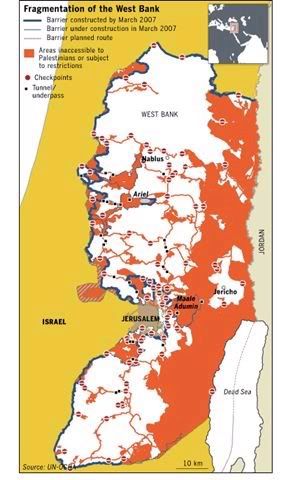
The map of the West Bank displayed above, 40 years after its occupation by Israel in the Six Day War, provides a definitive picture today of a territory in which 2.5 million Palestinians are confined to dozens of enclaves separated by Israeli roads, settlements, fences and military zones.
The map was produced by the United Nations’s Office for the Coordination of Humanitarian Affairs and is reproduced here in accordance with its copyright policy. It is reportedly based on extensive monitoring combined with what can be discerned from satellite imagery and it provides an overall picture that is more comprehensive than charts drawn up by the Israeli military, which are undoubtedly deceptive and intended to draw attention away from the colonization process. The Israeli justice ministry is quoted as saying that the report is “one-sided, immoral, and riddled with mistakes”. Did anyone expect differently? But how immoral is it to order Israeli occupation forces (IOF) to escort and protect Israeli settlers, while they destroy Palestinian olive groves and farmlands, or more recently, desecrate Palestinian cemetaries, or engage in house demolitions with IOF bulldozers, throwing entire families into the street?
The impact of Israeli settlements on the West Bank has essentially rendered 40 per cent of the territory, roughly the size of Delaware, off-limits to Palestinians. The rest of the territory shown in white, include main population centers such as Nablus and Jericho, which appear split off as isolated enclaves. Movement between them, according to the report, is “restricted by 450 roadblocks and 70 manned checkpoints.”
According to the authors,
The UN mapmakers focused on land set aside for Jewish settlements, roads reserved for settler access, the West Bank separation barrier, closed military areas and nature reserves.
What remains is an area of habitation remarkably close to territory set aside for the Palestinian population in Israeli security proposals dating back to postwar 1967. The process of enclosing the civilian enclaves has accelerated in the years since the outbreak of the Palestinian uprising in 2000, and the reintroduction by Israel of its military rule even in areas previously under Palestinian Authority security control.
A network of roads designed to ease the movement of Jewish settlers limits access between Palestinian enclaves. A secondary network being built would allow Palestinian limited movement via tunnels, bridges and trenches.
Diplomats say the effect of the infrastructure changes would be to formalise the de facto cantonisation of the West Bank. Some 450,000 Israelis live in the West Bank and occupied east Jerusalem and settlements have grown by at least 5.5 per cent a year compared with less than 3 per cent among Palestinians.
Amnesty was quoted as having issued a report (not available) that accused Israel of a land grab in the West Bank and called for urgent action to address “widespread human rights abuses committed under the occupation”.
The reoccupation of areas previously administered by the PLO under Arafat in the 1990s was obviously intended to fortify the colonization, which was under the direction of Ariel Sharon during most of this period, when settlement activity accelerated. The effect of these efforts is to ensure that Palestinians will receive no more than a Bantustan state. Although Oslo in retrospect was a farce for all but a short period during Rabin’s tenure as PM, it did give us insights into Israel’s modus operandi of talking peace, while continuing the occupation/colonization.
While people talk of peace and two state solutions, to this very day Israel’s government proceeds on its own agenda to continue the occupation/colonization process of Judea and Samaria started long ago. Although we speak of the “West Bank,” to Israelis and Israeli school children, it is Judea and Samaria that is in question. That Israel would ever remove cities of over 30,000 Israeli inhabitants, like Ariel located in the middle of the West Bank, is highly doubtful. The challenge to change Israel therefore continues: actions that contradict the very idea of peace are what must be stopped.
But the deception is cracking and more and more Americans are learning the simple truth, as evidenced in the above Map.
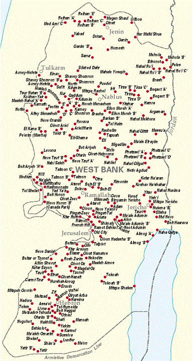
Although the UN Map appears complete, there is really something missing, namely, the locations of the 150 settlement villages, towns, and cities Israeli has built all over the West Bank. To complete the picture, a map of the largest of these settlements is shown below. They obviously crisscross through regions otherwise thought to be Palestinian enclaves.
A more detailed map from the UN Office of Humanitarian Affairs (below) shows in even greater detail the status of the West Bank and the bleakness of the geographic situation: large swaths of internal and border land have been consumed by the Wall to surround inland Israeli cities, Palestinian cities entrapped, and the Jordan Valley closed off (thanks to TarheelDem for the link).
http://www.ochaopt.org/documents/WestBank_March_07.pdf


