

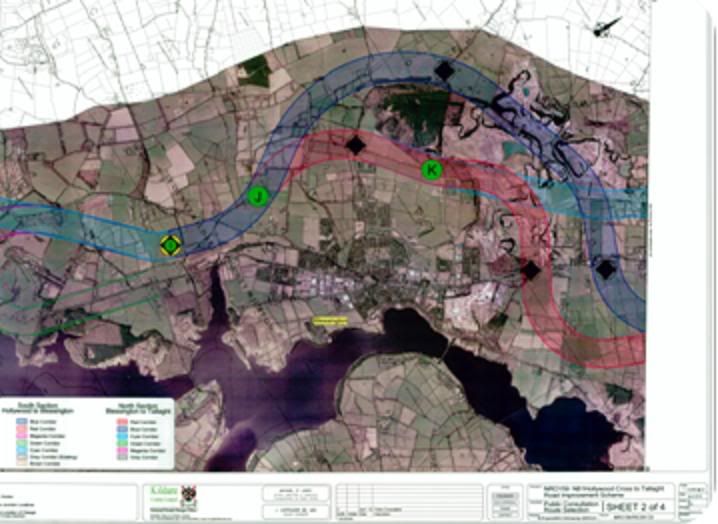
Just after I have committed myself to living in my home for the rest of my life and started to renovate and insulate it comes the joyous news by post that the road planning authorities want to drive a 50M wide dual carriageway though my home. The map above shows a number of proposed routes around the town of Blessington on the edge of Blessington lake. At this stage in the planning process the map only shows a number of 300M wide corridors within which the new road could be situated. The Blue Corridor runs right through my house. The cyan, red, blue and (barely visible) grey corridors run right through my brother-in-law’s farm rendering it likely to be inoperable or uneconomic as a working farm.
One of the routes also runs through the largely worked out quarries of Cement Roadstone Holdings Limited (CRH), one of the largest building materials companies in the world which employs 80,000 people and has not been behind the door in supporting politicians and parties it favours. CRH have been responsible for the illegal quarrying of much of Glen Ding and claims to have known nothing about the dumping of hundreds of thousands of rubbish there. Guess which route is unlikely to be chosen?
Obviously there are a lot of NIMBY reasons why no one would like to have a dual carriageway (basically a motorway but with some direct access for local roads) running through their property – especially in what has up to now been an idyllic rural area frequented by tourists and day trippers from Dublin. However the planning process which has led to these proposals almost defies belief and one can only surmise that the planning department is desperately trying to make work for itself and justify its continued existence now that most of the major national road re-development schemes have been completed.
The official Feasibility Report (PDF) for the road replacement scheme acknowledges that Blessington (population 4,000) is the only town on the route from the Embankment, Tallaght, (outside Dublin) and which is planned to terminate at Hollywood, a village with two pubs, no shop and a surrounding population of 700. So it is not as if the planned road is linking major population centres.
Moreover, Blessington, an historic tourist and recreation centre, is cradled in a valley between Blessington Lake (aka Poulaphouca reservoir) and Glen Ding and Deer Park – a range of glacial moraine hills which also contains the remains of Viking era ring forts and which is an important habitat for wild deer and goats. There is very little room for any major road to bypass Blessington without impinging on these outstanding recreational resources and visual amenities. While there are difficulties with the existing road, there are no problems which cannot be resolved by enhancing it at particular bottlenecks along its route.
I had a conversation with the N81 road re-development scheme engineer at an exhibition to publicise the proposals a few days ago, and what follows are the main points I put to him:
- The future traffic projections make no allowance for rapidly diminishing world oil supplies, the rapid increase in fuel costs and the impact of increasing the potential for road traffic on our carbon footprint and on climate change. It is thus contrary to public policy and the common good. The focus should be on improving public transport – either through an improved bus service or an extension of the Luas – a road based light rail scheme which is currently being extended to Saggart – the nearest town to Blessington on the way from Dublin. It should be noted, in this regard, that much of the existing N81 road route follows the old Dublin Blessington Steam Tram route which was closed in 1932. We are therefore going backwards, not forwards, in creating an ever greater dependency on private as opposed to public transport
- Kildare County Council should not be the lead local authority planning the route as most of the route is through Wicklow and this militates against the democratic accountability of the planning process. Wicklow County Council has previously attempted road realignment schemes in the area and have discontinued them in the face of widespread public opposition. The introduction of Kildare County Council as the lead authority could be interpreted as an attempt to bypass such popular opposition in the area.
- The traffic estimates appear to assume further population and commercial traffic growth. In fact the population of Blessington is static and the local sand and gravel quarries are closing or downsizing resulting in much reduced commercial traffic. (The engineer in charge of the project agreed that traffic surveys showed a significant decline in traffic on the route in recent years).
- The hinterland beyond Blessington is sparsely populated poor agricultural land and with no further commuter towns of note. Baltinglass and Tullow – the next towns beyond Hollywood – are small, 25-40 KM away and are not included on the National Spatial Strategy as population growth centres – and neither, for that matter, is Blessington. On what basis therefore could the development of a 50M wide dual carriageway be deemed to be necessitated by the National road planning process?
- In general, there is no significant congestion at the moment – even at rush hour. The current Tallaght bypass dual carriageway (which the new road is to connect to) is itself the biggest congestion point. If there is no plan to upgrade it to Motorway standard, any upgrade of the N81 simply exacerbates existing congestion at this point.
- What little congestion there can be is mainly at Jobstown (where the current road reduces from from 4 to 2 lanes), City West, Crooksling, and Brittas. This is caused by a winding, twisty road with few separate lanes for turning right – which means that any car turning right can block all traffic behind it until such time as gap appears in oncoming traffic.. This area is also prone to water run-off from the surrounding hills and icing in winter making it a safety hazard. The major public benefit from an enhancement/realignment of the road is in this section.
- The road between Brittas and Blessington is wide and straight for the most part and better utilisation of the existing space would enable the provision of a third lane for overtaking, climbing, and turning right at selected locations. This section should at most be widened, not replaced, and much of it could be widened to 4 lanes without difficulty. It is questionable whether 4 lanes are required for its entire length in any case, and consideration should be given to providing 3 lanes with an alternating overtaking lane where widening to four lanes is difficult.
- What little rush hour congestion there can be in Blessington village itself can best be alleviated by the extension of the inner relief road to the Hollywood road as initially planned. The junction of the inner relief road with the N81 north of Blessington should also be upgraded to a roundabout thus avoiding congestion created by there being no separate right turning lane there. This route would also avoid encroaching on Glen Ding and the scenic areas around it which are a vital scenic and historic amenity for the Blessington community and the many tourists and day trippers to the area.
- The red, blue and grey routes through Cross cool harbour (on the map above) are particularly objectionable and egregiously damaging to the environment and will hugely degrade a high amenity and Special Protection Area near Blessington Lake and destroy several farms and houses as well as passing close to two schools. In addition the routes also cut directly through the winter nesting and grazing sites of colonies of Hooper Swans and Brent geese which migrate from Iceland and Greenland respectively.
- The official Feasibility Report (PDF) claims that an average speed of 80 KPH is desirable for national roads and that the current N81 route only achieves 62KPH. However the average road speed tests conducted in conjunction with the Feasibility Study show that if the Blessington town section from the Red Lane junction to the roundabout south of Blessington is excluded, the average speed rises from 62 to c. 70 KPH. Indeed, based on the same data, the average speed from Crooksling to the Red Lane junction is 83KPH – which more than meets that notional national target, and indicates that the primary areas in need of improvement are the section around Blessington town and the route from Brittas to Tallaght. In addition the National Road Needs Study level of service guideline of 80 KPH applies to inter-Urban routes when neither Blessington nor Hollywood can be considered urban areas.
- All the potential routes chosen for the new road are very winding and add considerably to the total distance thus offsetting any time gains through increased speed.
- The Cyan route (Brittas-Blessington) is least deleterious to the environment as much of the route is through quarries which are closed or nearing the end of their working lives. Many of the worked out quarries are very environmentally degraded and a well designed road here could actually improve the environment in some respects. Indeed the sand/gravel geological composition of the area would facilitate the sinking of the road below the surrounding hills and reduce the environmental, noise and visual impact of the road – whilst the sand/gravel extraction facilitated by the road building could offset some of the development cost and carbon footprint.
As a former Chairman of Blessington and District Community Council (a voluntary body as there is no statutory Town Council for Blessington) I spent many years fighting against Cement Roadstone Holdings Limited (CRH) and often against the direct opposition of the Wicklow County Council which, in our view, had an altogether too cosy relationship with said company. CRH is one of the largest building materials companies in the world and employs 80,000 people and has not been behind the door in supporting local politicians and parties it favours.
CRH deserves a story all of its own, but suffice to say here that it’s former chairman was closely involved in the dodgy finances of disgraced former Taoiseach, Charles Haughey, managed to buy the historic Glen Ding from the state for a song without public competition, proceeded to simply remove most of it in the form of open cast mining of sand and gravel in breach of its planning permission and devastating an area of c. 1 square mile, and then mysteriously didn’t realise that its lorry drivers where bringing back hundreds of thousands of tons of waste which was then illegally dumped in their quarries.
The relevance of all this to this story, is that the CYAN route – which would least impact the local environment around Blessington lake – also happens to impinge on the CRH quarries which are now largely mined out and resemble something of a moonscape. From an environmental point of view a route through those largely worked out quarries, but avoiding what is left of Glen Ding would be the least environmentally damaging. However given the past close relationships between CRH and the local authorities, I wonder which route is also least likely to be chosen?


