
In a year chock full of examples of Mother Nature returning fire against an earth’s population hell bent on destroying her, she has fired another salvo. This time, it appears that she may be aiming for Nicaragua.
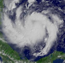 Meet Beta. Not yet a hurricane, but rapidly developing into one. The latest measurements from the National Hurricane Center tell us this tale:
GUSTS. STRENGTHENING IS FORECAST DURING THE NEXT 24 HOURS…AND
BETA COULD BECOME A HURRICANE LATE TONIGHT OR FRIDAY.
TROPICAL STORM FORCE WINDS EXTEND OUTWARD UP TO 60 MILES
… 95 KM FROM THE CENTER.
 |
While I’m not a big fan of the way that the NHS shouts all the time in their broadcasts, that doesn’t take away from their accuracy and reliability.
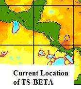
This could be a disaster in the making for Central America. Beta is currently moving very slowly, and over some very warm water. It could potentially develop into a major hurricane (cat-3 or higher) before making landfall. Nicaragua and Honduras may receive up to 20 inches of water in their interior mountainous regions, which could cause major flooding and mudslides. |
|
Water temperatures in the southwestern Caribbean, near Tropical Storm Beta
|
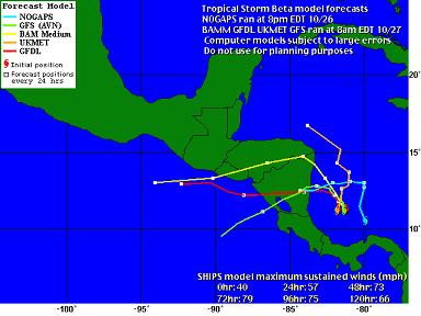
All of the most recent computer models except the UKMET currently have Beta hitting Nicaragua one way or another. UKMET shows it skipping up towards the Yucatan, but I don’t even want to speculate on what that might mean after the damage Wilma already inflicted on that area.
Jeff at Weather Underground has this to say:
As he says, there is no way to know exactly where this thing is headed (as we’ve seen all throughout this year). But it could be a major, major disaster for our Central American cousins. Landfall is currently being predicted at sometime early on Sunday morning.
Finally, if you were curious about what happens if a hurricane bearing a greek letter designation is to be retired, Jeff doesn’t know for sure either:
everyone might want to stay up to date on the hurricane that isn’t about to hit Washington 🙂
Beta looks like it’s going to affect “them”, no skin off “our” noses!
till this year that they didn’t use all 26 letters in the alphabet for hurricane names. I was really hoping for a Hurricane Xerxes…
Then again, it wasn’t that long ago that hurricanes/tropical storms only had women’s names…
Maybe they could go to the Hebrew alphabet: Hurricane Gimel has a nice ring to it for some reason…
As opposed to the hurricane about to hit DC, which should be called hurricane Xena, as it damages evil war lords!
n/t
There are 214 of those, I think.
Too difficult for all the TV weatherpeople to pronounce, I’m sure 😉
Glad my son took his vacation in Costa Rica last week.
At some point in time (which seems to be happening sooner rather than later) global warming may make the Caribbean basin and the Gulf Coast uninhabitable during the hurricane season.
It certainly is a frightening thought, isn’t it?
At the very least, just think of all the maps that are going to have to be reprinted after the geography is so heavily changed down there.
000
JACKSON MSGHW 7984498
TCPRC1
GLOBAL HEATING FORECAST/ADVISORY NUMBER 647
NGH GPC/NATIONAL GLOBAL HEATING CENTER JACKSON MS BT262005
1500Z THU OCT 27 2005
AT 11 AM EDT…1500Z…THE FROG POND OF BOOTRIB HAS ISSUED A GLOBAL HEATING WARNING FOR THE ENTIRE PLANET
WATCH FOR THE EFFECTS OF GLOBAL HEATING FROM THE CARRIBEAN TO THE GULF OF MEXICO NORTHWARD TO THE EASTERN US COAST…AND ADJACENT ISLANDS. A GLOBAL HEATING STORM WARNING IS ALSO IN EFFECT FOR THE ENTIRE PLANET.
A GLOBAL HEATING WARNING MEANS THAT SEVERE CLIMATIC EXTREMES ARE EXPECTED WITHIN THE WARNING AREA WITHIN THE NEXT 24 HOURS. PREPARATIONS TO PROTECT LIFE AND PROPERTY SHOULD BE RUSHED TO COMPLETION.
GLOBAL HEATING STORM CENTER LOCATED EVERYWHERE AT 27/1500Z
POSITION ACCURATE WITHIN 25 NM
PRESENT MOVEMENT TOWARD THE NORTH AT 3 DEGREES CELSIUS.
ESTIMATED MINIMUM CENTRAL TEMPERATURE IS RISING QUICKLY .
MAX SUSTAINED HOT-HOUSE WINDS 160 KT WITH GUSTS TO 175 KT.
WINDS AND SEAS VARY GREATLY IN EACH QUADRANT.
REPEAT…CENTER LOCATED NEAR YOU
AT 27/1200Z CENTER WAS LOCATED NEAR YOU.
EXTENDED OUTLOOK. RAPIDLY INCREASING TEMPERATURES EXPECTED FOR DECADES TO COME, CAUSING SEVERE INLAND HURRICANES, RISING SEA LEVELS YIELDING EXTENSIVE COASTAL FLOODING, AND MASSIVE INCREASES IN THE SPREAD OF TROPICAL DISEASES.
GLOBAL HEATING HAS BEEN ELEVATED TO A CATEGORY 5 STORM, AND IT MAY BE HEADED FOR YOUR NEIGHBORHOOD SOON.
NEXT ADVISORY AT 27/2100Z
FORECASTER BLUENECK
$$
UNLESS CORRECTIVE ACTIONS ARE TAKEN IMMEDIATELY, BOOTRIBBERS MAY BE FORCED TO RELOCATE TO MORE NORTHERLY LATITUDES TO ESCAPE THE WORST EFFECTS OF THE RESULTING DESTRUCTION. CANADIAN, ALASKAN, ICELANDIC, AND SCANDINAVIAN BLOGGERS ARE ADVISED TO BE HOSPITABLE TO GLOBAL HEATING / POLITICAL SHITSTORM REFUGEES FROM THE MAINLAND USA.
Continuing my link-drops for those interested:
When the satellite is in correct position, this site has graphics of the latest wind fields: QUIKSCAT NRT Winds – Current Storm over Atlantic Ocean
This site has some nice downloadable gif loops of the latest storm: Plymouth State Weather Center – Tropical Weather Menu
LSU has a nice site with some downloadable gif loops of satellite views of the Gulf, but this is a nice color representation of the latest water vapor image: The latest ‘hot-shot’ water vapor satellite view of the Carribean/Gulf from LSU
AND, worth repeating, the best satellite site on the net, run by the U.S.Navy: Navy Tropical Center – Satellite Pictures Galore!
If BETA becomes a hurricane, I have a few more links for later….. 🙂