
And now my friends the time has come to talk of other things, of shoes and ships and sealing wax. Of cabbages and kings.

the king, aka: the poseur, pan troglodytes l, knee deep in mess-0-potamia, hammer in hand, and having been given free reign since nine, one, one, has apparently been much busier and nosier than many have suspected. however, with all the attention being paid to the electronic surveillance and data mining, vis-a-vis, the internet, etc., not much attention has been paid to other forms of surveillance on the publics expectation of 4th amendment rights/protections, specifically, aerial and satellite based methods.
but fear not, dear reader, they have not been neglected.
[…]
the national reconnaissance office never sleeps, in fact, their motto is we own the night
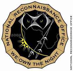

As part of the 16-member Intelligence Community, the NRO plays a primary role in achieving information superiority for the U. S. Government and Armed Forces.
A DoD agency, the NRO is staffed by DoD and CIA personnel. It is funded through the National Reconnaissance Program, part of the National Foreign Intelligence Program.
Our Vision:
Freedom’s Sentinel in Space: One Team, Revolutionizing Global Reconnaissance.
now, l grant you, “freedom’s sentinel” may be a bit hyperbolic, especially in light of the recent “congressional compromise” over fisa oversight in the face of losing their summer recess and afternoon nap; and, it would surely be ungrateful of me to question the commitment these brave sentinels of freedom have made…but these guys have a lot on their plate. being the gatekeepers to space, and all the evil that’s surely lurking out there.
for example:
Aug. 09, 2007 | In the pre-dawn hours of Sept. 1, 2005, a U-2 surveillance aircraft known as the Dragon Lady lifted off the runway at Beale Air Force Base in California, the home of the U.S. Air Force 9th Reconnaissance Wing and one of the most important outposts in the U.S. intelligence world. Originally built in secret by Lockheed Corp. for the Central Intelligence Agency, the U-2 has provided some of the most sensitive intelligence available to the U.S. government, including thousands of photographs of Soviet and Chinese military bases, North Korean nuclear sites, and war zones from Afghanistan to Iraq.
But the aircraft that took off that September morning wasn’t headed overseas to spy on America’s enemies. Instead, for the next six hours it flew directly over the U.S. Gulf Coast, capturing hundreds of high-resolution images as Hurricane Katrina, one of the largest storms of the past century, slammed into New Orleans and the surrounding region.
The U-2 photos were matched against satellite imagery captured during and after the disaster by the National Geospatial-Intelligence Agency. Relatively unknown to the public, the NGA was first organized in 1996 from the imagery and mapping divisions of the CIA, the Department of Defense and the National Reconnaissance Office, the agency that builds and maintains the nation’s fleet of spy satellites. In 2003, the NGA was formally inaugurated as a combat support agency of the Pentagon. It is responsible for supplying overhead imagery and mapping tools to the military, the CIA and other intelligence agencies — including the National Security Agency, whose wide-reaching, extrajudicial spying inside the United States under the Bush administration has been a heated political issue since first coming to light in the media nearly two years ago.
The NGA’s role in Hurricane Katrina has received little attention outside of a few military and space industry publications. But the agency’s close working relationship with the NSA — whose powers to spy domestically were just expanded with new legislation from Congress — raises the distinct possibility that the U.S. government could be doing far more than secretly listening in on phone calls as it targets and tracks individuals inside the United States. With the additional capabilities of the NGA and the use of other cutting-edge technologies, the government could also conceivably be following the movements of those individuals minute by minute, watching a person depart from a mosque in, say, Lodi, Calif., or drive a car from Chicago to Detroit.
more via salon
…raises the distinct possibility…yep, that is does. given this administration’s, and those that have preceded it, propensity to push the envelope and then some, l’d posit that it’s, more likely than not, extremely probable.
frankly, l find the basic premise behind basing U2 aircraft in california, somewhat perplexing…why? the obvious answer: they were already being utilized for some purpose…unknown…other than the ME. in short, l find it difficult to to buy into the concept that you base airborne surveillance aircraft of this nature 10,000 miles away from their most likely targets, especially single seat aircraft such as the U2.
additionally, the latest revelation of the vastly expanded access to local and federal agencies to classified intelligence data obtained via satellite is not encouraging news:
…Director of National Intelligence Michael McConnell decided to increase access to the spy data earlier this year and asked Homeland Security Secretary Michael Chertoff to facilitate access to the spy data by civilian agencies and law enforcement.
Previously, access to only the most basic spy-sattelite [sic] data was limited to a handful of federal civilian agencies, such as NASA and the US Geological Survey, which used the images for scientific and environmental study.
The move to turn spy satellites on American citizens raises legal questions because the use of such data for law enforcement is “largely uncharted territory.” Even the officials behind the move were unsure of its legal implications, the Journal reports.
[…]
“You are talking about enormous power,” Gregory Nojeim, senior counsel and director of the Project on Freedom, Security and Technology for the Center for Democracy and Technology told the paper. “Not only is the surveillance they are contemplating intrusive and omnipresent, it’s also invisible. And that’s what makes this so dangerous.”
wsj via rawstory
enormous power, indeed. at last count, back in dec 2005, there are a lot of things we may, or may not, be aware of up there.
WASHINGTON (AP) — The United States has 413 satellites in space snooping for the government, checking on the weather and relaying the latest pop music, a new database says. That’s more than the 382 the rest of the world has spinning above the Earth.
The inventory, developed by the Union of Concerned Scientists and released Wednesday, provides details on some of the Pentagon’s most secret satellites, which may gather images in the dark or take high-resolution pictures from 12,000 miles away.
[…]
combined with the the capability to keep in touch with you via your computer, telecom/cable land lines, gps imbedded cell phones and automobiles, etc., combined with the latest in aerial/space based systems, it’s getting harder and harder to maintain the ideal that there’s such a thing as the 4th amendment left.
as unpleasant as it may be to contemplate, whatever expectations you may have harboured regarding privacy, well, they’re pretty much outdated unless you live in a cave…which seems to have worked out rather well for osama b’s life-expectancy. but rest assured, you’re never alone.
tips, recs, whatever
lTMF’sA
dada, how exciting it is to be in the 21st century, now isn’t it??!!
Great article BTW..Thanks for the wonderful news you shared with us here. hugs and keep bring us more of the same. We all need this to keep us on our toes.
Prophetic lyrics:
Link
Eye in the sky
(Alan Parsons Project)
MUSIC Don’t think sorry’s easily said.
Don’t try turnin’ tables instead.
You’ve taken lots of chances before,
but I ain’t gonna give anymore;
don’t ask me.
That’s how it goes,
’cause part of me knows
what you’re thinkin’.
Don’t say words you’re gonna regret.
Don’t let the fire rush to your head.
I’ve heard the accusation before,
and I ain’t gonna take anymore;
believe me.
The sun in your eyes
made some of the lies
worth believing.
I am the eye in the sky
looking at you;
I can read your mind.
I am the maker of rules,
dealing with fools;
I can cheat you blind.
And I don’t need to see anymore to know that
I can read your mind
lookin’ at you,
I can read your mind
lookin’ at you,
I can read your mind
lookin’ at you,
I can read your mind.
Don’t leave false illusions behind.
Don’t cry, I ain’t changin’ my mind.
So find another fool like before,
’cause I ain’t gonna live anymore
believin’ some of the lies,
while all of the signs
are deceiving.
I am the eye in the sky
looking at you;
I can read your mind.
I am the maker of rules,
dealing with fools;
I can cheat you blind.
And I don’t need to see anymore to know that
I can read your mind
lookin’ at you,
I can read your mind
lookin’ at you,
I can read your mind
lookin’ at you,
I can read your mind.
When compared to the total time frame of the history of man Hitler’s regime did not occupy a major time slot. So too will this regime’s penchant for assholianism disappear. In the meantime I propose a simple gesture to be used to mock this staged increase in authoritarianism.
Come to attention by clicking your heels together like the Nazis did. Then take the two fingers of your right hand and raise them as if to salute. Instead cover your upper lip in a manner mocking Hitler’s silly moustache.
Thousand year reich, yeah, that lasted.
This won’t either but I still don’t know if I get the Apocalypse horse ride out of the whole deal or not.
your companions are coming
clik
lTMF’sA