

OK folks, I have to go to bed soon, but I think this is important.
Hurricane Wilma has strengthened over the last 12 hours in nearly unprecedented rapidity. The folks on the weather channel are just about choking on their tongues trying to describe this right now.
As they say in Star Wars : I’ve got a bad feeling about this.
More on the flip.
Here is what Steve Gregory, from Weather Underground had to say on his blog. This sends chills down my spine.
RECON JUST REACHED. WILMA IT IS AN UNBELIEVABLE SUPER CAT 5 –> 901MB, WITH 162kts!!!!
OVER A 50mb DROP IN 5 HOURS – THE SAME RATE AS RITA. 2 MORE HOURS OF THIS IT COULD EASILY BREAK THE ALL TIME
RECORD LOW PRESSURE IN THE ATLANTIC BASIN OF 888MB.IMAGERY SUPPORTS THIS. And the 850mb height was reported at 516 meters.
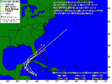
The models that have been run lately on their site show this hurricane hitting Mid/Southern Florida in a few days. (pictures borrowed from Weather Underground).
From Jeff Masters’ blog, here is a map of the water temps in the Gulf right now:
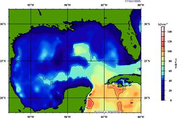
From Jeff:
Wilma is currently traversing an area of high oceanic heat content (see Figure 1), and this heat content will not significantly fall unless Wilma passes north of the Florida Keys. I would expect an additional 10 mph reduction in Wilma’s winds if she makes landfall in Florida north of the Keys, due to the lower heat content of the water.
It should be noted that he last updated this several hours ago, and was predicting a cat-2 at landfall. I’m pretty sure he will be changing that prediction when he gets up in the morning, but if the relative wind speed prediction stays the same, this could be disastrous.
The eye of the storm is only 4 miles across right now. This is an amazingly intense hurricane.
Note : I am not a meteorologist. People who are are using words like explosive and phenomenal to describe what is going on right now. Phrases like I’ve never seen a drop in pressure like this in an Atlantic Basin hurricane and I’ve never seen an eye this small.
Wikipedia has folks keeping their page extremely up to date, as always.
Update [2005-10-19 9:31:26 by ejmw]:From Jeff Masters:
There has never been a hurricane like Wilma before. With an unbelievable round of intensification that saw the pressure drop 85 mb in just 12 hours, Wilma smashed the all-time record for lowest pressure in an Atlantic hurricane this morning.
Thanks to brinnaine and blueneck for keeping the light on while I got some much needed shuteye.
Update [2005-10-19 22:24:28 by ejmw]:Wilma’s pressure came back up today to 892 mb, which is 10 mb higher than it’s frightening low of 882 mb.
Note that this still means that Wilma is as strong as the third most powerful hurricane ever measured, the <a href="http://en.wikipedia.org/wiki/Labor_Day_Hurricane_of_1935"Labor Day Hurricane of 1935.
From Jeff’s weather blog:
Peak winds measured at flight level were 141 knots in the southern eyewall, compared to 162 knots measured this morning.
(…)
The eye diameter measured by the hurricane hunters was still a very tiny 5 nm, and an second concentric eyewall with diameter 10 nm has formed. This indicates that Wilma may soon undergo an eyewall replacement cycle, and will weaken to a Category 4 storm.
After the eyewall replacement cycle is complete, the hurricane could potentially strengthen again, but hopefully it will be headed over cooler waters or land by that time.
In addition, if it hits the Yucatan peninsula, that could help to weaken it significantly as well. While this is good news for Florida, it is very bad news for Mexico, as there is a chance that it may hit as a cat-4 at landfall.
Here are the latest computer models from Weather Underground:
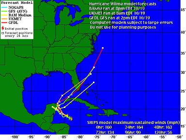
I think that the models tomorrow will tell us more, as there is a great degree of unpredictability right now. You can see that the computer models are much less tightly clustered than they were last night and earlier today.
I’ll try to keep this updated as long as it stays on the rec list. Folks on dial up, let me know if this starts getting too slow and I’ll start to remove some of the old pictures or start a new thread.


